
Commercial Satellite Imaging Market Research Report Information By Application (Geospatial Data Acquisition Mapping, Defense & Intelligence, Energy, Surveillance & Security, Disaster Management), By End-User (Commercial, Defense), By Type (Small, Middle, Large) And By Region (North America, Europe, Asia-Pacific, And Rest Of The World) -Market Forecast Till 2032
Commercial Satellite Imaging Market Overview
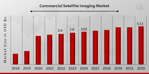
The commercial satellite imaging market [https://www.marketresearchfuture.com/reports/commercial-satellite-imaging-market-3249] is witnessing significant growth, driven by the increasing demand for high-resolution imagery across various industries such as agriculture, defence, urban planning, and environmental monitoring. The ability to capture detailed images of the Earth’s surface from space has transformed how businesses and governments make informed decisions. As technology advances and data analytics improve, the commercial satellite imaging industry is poised to reach new heights, presenting vast opportunities for stakeholders across the globe. The Commercial Satellite Imaging market is expected to expand from USD 3.02 billion in 2024 to USD 5.11 billion by 2032, registering a compound annual growth rate (CAGR) of 6.80% during the forecast period (2024-2032).
Image: https://www.abnewswire.com/upload/2025/02/4bc44bd19d3f81a197fb8775ed3636aa.jpg
Get a Quote – Request a price quote for the report or specific research services. [https://www.marketresearchfuture.com/sample_request/3249]
Commercial satellite imaging refers to the use of Earth observation satellites to capture detailed images and provide geospatial data for commercial applications. These images are utilized in a wide range of sectors, including disaster management, forestry, mining, and real estate. The integration of artificial intelligence (AI) and machine learning (ML) has further enhanced image processing capabilities, allowing for more accurate and timely analysis of geospatial data. With the rising adoption of satellite-based imagery for strategic decision-making, the market is expected to experience substantial growth in the coming years.
Competitive Landscape
The Commercial Satellite Imaging market is driven by key players across various regions, each contributing to advancements in satellite imaging technology and data analytics. Companies such as UrtheCast (Canada) and European Space Imaging (Germany) are leading the market in their respective regions, leveraging advanced satellite solutions for diverse applications. In the United States, major players include BlackSky, Exelis Inc., Planet Labs Inc., Harris Corporation, SpaceKnow, and DigitalGlobe, all of which are at the forefront of satellite imaging, providing high-resolution imagery for defines, agriculture, and environmental monitoring. Airbus (France) is a dominant force in Europe, offering cutting-edge satellite imaging solutions, while Galileo Group Inc. (U.S.) specializes in geospatial intelligence and remote sensing. These companies continue to shape the industry through innovation, strategic partnerships, and expanding commercial applications.
Commercial Satellite Imaging Industry Developments
December 2022 Scientists from the European Space Agency (ESA) continued to monitor the Alps’ snow conditions, ice cover, and continuous snow region. The Copernicus satellite collects this data. To possess greater skill and expertise. In order to predict changes on a worldwide scale, the Copernicus Sentinel-3 mission satellite studies the seas, continents, polar regions, and atmosphere.
Key Market Drivers
One of the primary drivers of the commercial satellite imaging market is the increasing demand for high-resolution satellite imagery for security and defense applications. Governments and defense organizations rely on satellite imagery for border surveillance, intelligence gathering, and disaster response. Additionally, advancements in imaging technologies, such as hyperspectral and multispectral imaging, have expanded the potential applications of commercial satellite imagery.
The agricultural sector is also leveraging satellite imaging to enhance productivity and optimize resource usage. Precision farming techniques utilize satellite-based data to monitor crop health, assess soil conditions, and predict yields. Similarly, urban planning and infrastructure development projects rely on satellite imagery to assess land use patterns and manage resources efficiently.
Moreover, the growing need for environmental monitoring and climate change assessment is fueling the demand for satellite imaging. Governments and environmental organizations use satellite data to track deforestation, monitor air and water quality, and assess the impact of natural disasters. This increased awareness of climate-related issues is expected to drive further adoption of satellite imaging solutions.
Market Segmentation
The commercial satellite imaging market can be segmented based on application, end-user industry, and geography.
* By Application: The market includes sectors such as defense and intelligence, agriculture, environmental monitoring, urban planning, disaster management, and mining.
* By End-User Industry: Key industries utilizing satellite imaging include government and military, agriculture, energy, forestry, and real estate.
* By Geography: The market is segmented into North America, Europe, Asia-Pacific, Latin America, and the Middle East and Africa. North America holds a dominant position due to the presence of leading satellite imaging companies and strong government investments in space technology.
Buy Now – Take immediate action to purchase the full report and access all the valuable information it contains. [https://www.marketresearchfuture.com/checkout?currency=one_user-USD&report_id=3249]
Future Outlook
The future of the commercial satellite imaging market looks promising, with continuous technological advancements and increasing investments in satellite launches. The introduction of small satellites, also known as CubeSats, is reducing the cost of satellite imagery, making high-resolution geospatial data accessible to a broader audience. Furthermore, the adoption of AI and cloud computing is enhancing the analytical capabilities of satellite imaging, providing more actionable insights for various industries.
As the demand for real-time geospatial intelligence grows, the market is expected to witness increased collaboration between satellite imaging companies and sectors such as telecommunications, transportation, and disaster management. Additionally, government initiatives aimed at space exploration and satellite-based communication will further contribute to market expansion.
Frequently Asked Questions (FAQ) :
How much is the Commercial Satellite Imaging market?The Commercial Satellite Imaging Market size was valued at USD 2.8 Billion in 2023.
What is the growth rate of the Commercial Satellite Imaging market?
The Commercial Satellite Imaging Market is projected to grow at a CAGR of 6.80% during the forecast period, 2024-2032.
Which Region held the largest market share in the Commercial Satellite Imaging market?North America had the largest share in the Commercial Satellite Imaging Market.
Discover More Research Reports on Aerospace & Defence by Market Research Future:
Unmanned Aerial Vehicle (UAV) Market Research Global Forecast To 2030 [https://www.marketresearchfuture.com/reports/unmanned-aerial-vehicle-uav-market-806]
About Market Research Future:
Market Research Future (MRFR) is a global market research company that takes pride in its services, offering a complete and accurate analysis with regard to diverse markets and consumers worldwide. Market Research Future has the distinguished objective of providing optimal quality research and granular research to clients. Our market research studies by products, services, technologies, applications, end users, and market players for global, regional, and country level market segments, enable our clients to see more, know more, and do more, which help answer your most important questions
Contact Us:
Market Research Future (Part of Wantstats Research and Media Private Limited)
99 Hudson Street, 5Th Floor New York,
10013 United States of America+1 628 258 0071 (US)
+44 2035 002 764 (UK)
Email: info@marketresearchfuture.com
Follow Us: LinkedIn | Twitter
Website: https://www.marketresearchfuture.com/
https://www.wiseguyreports.com/
Media Contact
Company Name: Market Research Future
Contact Person: Media Relations
Email:Send Email [https://www.abnewswire.com/email_contact_us.php?pr=commercial-satellite-imaging-market-to-reach-usd-511-billion-at-680-cagr-20242032-driven-by-advancements-in-satellite-technology]
Country: United States
Website: https://www.marketresearchfuture.com
Legal Disclaimer: Information contained on this page is provided by an independent third-party content provider. ABNewswire makes no warranties or responsibility or liability for the accuracy, content, images, videos, licenses, completeness, legality, or reliability of the information contained in this article. If you are affiliated with this article or have any complaints or copyright issues related to this article and would like it to be removed, please contact retract@swscontact.com
This release was published on openPR.


